By Editorial Staff
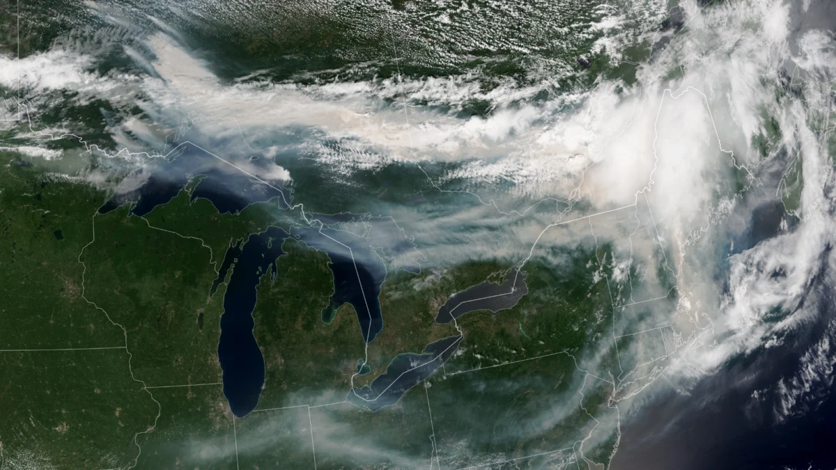
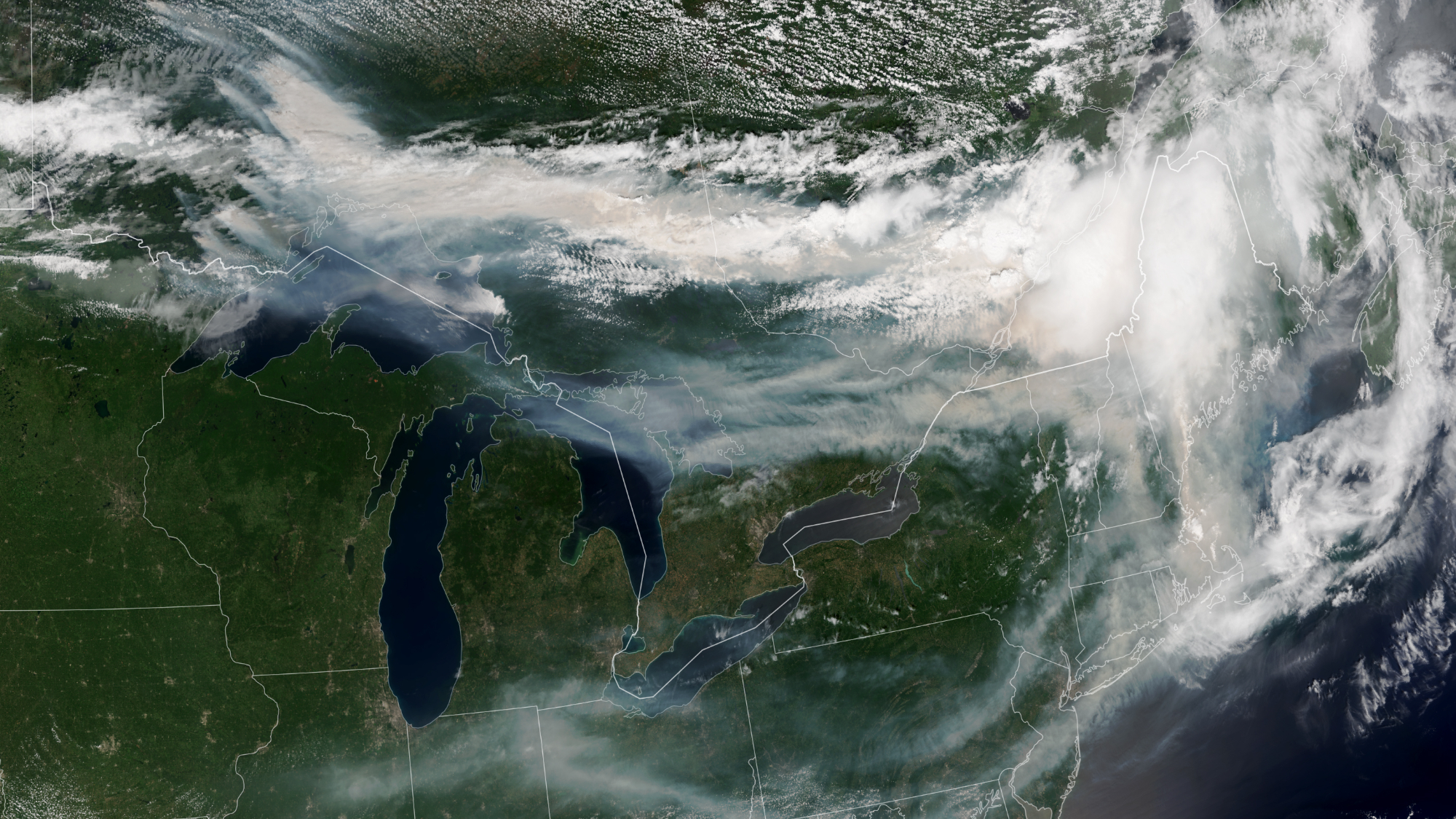
The horizon across North America has taken on an eerie, sepia-toned hue this July, as a massive expanse of smoke originating from Canada’s northern forests drifts southward, blanketing the northeastern United States. Satellite imagery captured on July 14, 2026, by the NOAA-21 spacecraft provides a sobering perspective on the crisis: thick, billowing plumes of particulate matter are visible from low Earth orbit, stretching from the interior of Canada across the international border and deep into the American Northeast.
According to the Canadian Interagency Forest Fire Center (CIFFC), over 850 active wildfires are currently consuming vast tracts of wilderness. As these blazes continue to burn with unrelenting intensity, they are not only reshaping the Canadian landscape but also triggering a public health emergency that has forced officials in New York and surrounding states to activate emergency air quality protocols.
Main Facts: A Continent Under Siege
The current wildfire season has reached a critical threshold, characterized by an unusually high number of simultaneous, uncontrolled ignitions. While wildfires are a natural component of boreal forest ecosystems, the scale and frequency observed this year have far exceeded historical averages.
The primary regions currently under duress include Manitoba, Saskatchewan, and Ontario. In these provinces, the fire load has overwhelmed local suppression efforts. The smoke generated by these infernos is not merely a local concern; atmospheric currents have channeled the plumes into a massive "smoke corridor" that descends over the Great Lakes and into the densely populated Northeast corridor of the United States.
On Thursday, July 16, air quality sensors across New York recorded levels of particulate matter (PM2.5) that reached "very unhealthy" thresholds. This microscopic soot is small enough to penetrate deep into the human respiratory system and enter the bloodstream, posing significant risks to children, the elderly, and individuals with underlying respiratory or cardiovascular conditions.
Chronology of the 2026 Firestorm
The escalation of this crisis did not occur overnight. It is the culmination of a sequence of climatic and environmental factors that primed the landscape for disaster:
- Early Spring (March–April 2026): Unseasonably warm temperatures led to an early snowmelt across the Canadian Prairies and Ontario. This left the forest floor, typically protected by a damp layer of snow-melt, exposed to dry winds and rising temperatures much earlier than in previous years.
- Late May 2026: Small, lightning-induced fires began to break out in remote regions of Saskatchewan. Due to the extreme remoteness and the number of concurrent starts, firefighting resources were stretched thin immediately.
- Late June 2026: A persistent "heat dome" settled over central Canada, driving temperatures to record highs. This period marked the beginning of the transition from manageable fires to the "megafire" behavior currently observed, where flames generate their own localized weather systems, including pyrocumulus clouds.
- July 14, 2026: The NOAA-21 satellite, equipped with the Visible Infrared Imaging Radiometer Suite (VIIRS), captured the image that would define the crisis. The data showed a near-continuous blanket of smoke covering southeastern Canada and trailing into the U.S. Northeast.
- July 16, 2026: U.S. state governments officially declared air quality emergencies, advising citizens to remain indoors and avoid strenuous physical activity as the smoke reached peak density in the tri-state area.
Supporting Data: What the Satellites Tell Us
The role of satellites in modern disaster management cannot be overstated. Instruments like the VIIRS on the NOAA-21 satellite serve as the "eyes in the sky" for fire managers on the ground.
The Science of Remote Sensing
VIIRS works by measuring the intensity of light and heat radiation across the electromagnetic spectrum. It allows scientists to distinguish between active "hot spots" (the flames themselves) and the expansive plumes of aerosolized smoke. By tracking these plumes, meteorologists can create highly accurate models to predict where the air quality will deteriorate next, allowing local governments to issue timely health warnings.
Quantifying the Smoke
The density of the smoke is measured through "Aerosol Optical Depth" (AOD), a metric that quantifies how much sunlight is obscured by particles in the atmosphere. Current readings from affected areas show AOD levels nearly five times higher than the regional average for mid-July. This data serves as a diagnostic tool for researchers studying the intersection of wildfire emissions and climate change, providing a real-time ledger of the carbon and particulate matter being released into the atmosphere.
Official Responses and Public Health Mandates
As the smoke settled over the Northeast, the response from public officials was swift. In New York, the Department of Environmental Conservation activated emergency air quality protocols, which included the distribution of N95 masks to vulnerable populations and the temporary closure of outdoor public facilities.
"We are dealing with an atmospheric event that is unprecedented in its reach," said one regional health official during a press briefing on July 16. "The priority is to minimize exposure. Even if you cannot see the smoke, the fine particulate matter is present. We urge residents to treat this as a serious health event, similar to a severe storm."
In Canada, federal authorities have requested international assistance, coordinating with firefighting crews from the United States, Mexico, and Australia to bolster the ranks of local fire suppression teams. However, officials acknowledge that for many of the remote, uncontrolled fires, the primary strategy is containment and the protection of critical infrastructure, as full suppression is physically impossible given the scale of the forest burning.
Implications: The Climate Change Connection
The devastation of the 2026 fire season serves as a stark, empirical manifestation of climate change. For decades, climatologists have warned that as global temperatures rise due to the combustion of fossil fuels—most notably coal, oil, and natural gas—the natural volatility of our climate would increase.
The "New Normal"
The connection between human-driven climate change and wildfire intensity is threefold:
- Fuel Desiccation: Higher average temperatures and lower humidity levels dry out vegetation, turning forests into tinderboxes.
- Extended Seasons: The window of time in which forests are vulnerable to ignition is lengthening. What used to be a three-month fire season is now stretching into five or six months.
- Atmospheric Instability: Climate change alters jet stream patterns, often resulting in "stagnant" weather systems. This allows heat domes to persist over a region for weeks at a time, preventing cooling and fueling the growth of fires.
Long-term Outlook
The long-term implications are profound. Beyond the immediate loss of timber, biodiversity, and property, these fires represent a massive release of stored carbon into the atmosphere. This creates a dangerous feedback loop: more fire leads to more carbon emissions, which leads to higher temperatures, which leads to even more intense wildfires.
As we look toward the future, the integration of satellite data into global policy becomes essential. If the 2026 fire season is a precursor to the coming decades, nations will need to rethink urban planning, forest management, and energy policies. The images captured by NOAA-21 are more than just pictures of a burning landscape; they are a warning from the planet itself, suggesting that the era of manageable, localized disasters has passed, and we are entering an age where the consequences of our atmospheric footprint are visible from the stars.
As the fires in northwestern Ontario continue to burn, the global community watches through the lens of satellites, waiting for the weather patterns to shift and the skies to clear. Until then, the smoke remains a haunting reminder of the fragility of our environment and the pressing need for systemic change.