PARIS — In a move that intensifies the global race for sub-quarter-meter commercial Earth observation, South Korean satellite manufacturer Satrec Initiative has announced a strategic expansion of its orbital pipeline. Working in close coordination with its parent company, Hanwha Systems, the Daejeon-based space firm plans to develop and launch a constellation of four ultra-high-resolution optical satellites capable of capturing 10-centimeter-class imagery.
This new optical fleet is designed to directly complement Hanwha Systems’ ambitious, previously announced 64-satellite synthetic-aperture-radar (SAR) constellation. By fusing day-and-night radar capabilities with ultra-precise optical imagery, the combined network aims to deliver unprecedented "Satellite as a Service" (SaaS) offerings tailored for the global defense, intelligence, and national security sectors.
Main Facts: Fusing Optical and Radar Capabilities
At the heart of the joint Hanwha-Satrec initiative is a multi-modal orbital architecture designed to overcome the traditional trade-offs of Earth observation. While optical satellites provide highly detailed, easily interpretable semantic data, they are inherently limited by cloud cover and darkness. Conversely, SAR satellites can penetrate weather anomalies and operate in complete darkness but produce radar backscatter imagery that requires specialized analysis to interpret.
By pairing these two sensor modalities, the companies intend to establish a continuous "tip-and-cue" monitoring loop:
The Tip: Hanwha’s 64-satellite SAR constellation, slated to achieve a rapid 30-minute revisit rate by 2031, will continuously scan areas of interest, instantly flagging physical changes, maritime movements, or construction activities regardless of cloud cover.
The Cue: Once an anomaly is detected by the SAR network, Satrec’s 10-centimeter optical satellites will be tasked to capture high-fidelity imagery, providing intelligence analysts with the visual clarity needed for positive identification.
The Intelligence: The raw imagery from both networks will be routed through SI Analytics, a subsidiary of Satrec Initiative, which leverages proprietary artificial intelligence algorithms to automate target detection, change mapping, and predictive analysis.
Chronology: The Road to Ultra-High Resolution
The integration of Satrec Initiative and Hanwha Systems represents a multi-year consolidation of South Korea’s domestic space industrial base, transitioning from state-backed research projects to an aggressive commercial export model.
  2021: Hanwha Aerospace acquires a controlling 30% stake in Satrec Initiative.
    │
    ▼
  2025: Launch of SpaceEye-T, Satrec's flagship 25-cm optical satellite.
    │
    ▼
  July 2026: Hanwha Systems publicly announces its 64-satellite SAR constellation.
    │
    ▼
  September 2026: Satrec Initiative unveils 10-cm VLEO optical plans at WSBW in Paris.
    │
    ▼
  Near-Term Future: Launch of a test satellite into a 500-km orbit to validate VLEO tech.
    │
    ▼
  2031: Full operational capability of the 64-satellite SAR and VLEO optical network.
The Partnership Origin (2021)
The groundwork for this capability was laid in early 2021 when Hanwha Aerospace, a defense conglomerate, acquired a strategic 30% stake in Satrec Initiative for approximately $98 million. This acquisition effectively wedded Satrec’s decades of heritage in high-performance Earth observation cameras and small satellite manufacturing with Hanwha’s massive industrial scale, defense relationships, and aerospace engineering resources.
The Launch of SpaceEye-T (2025)
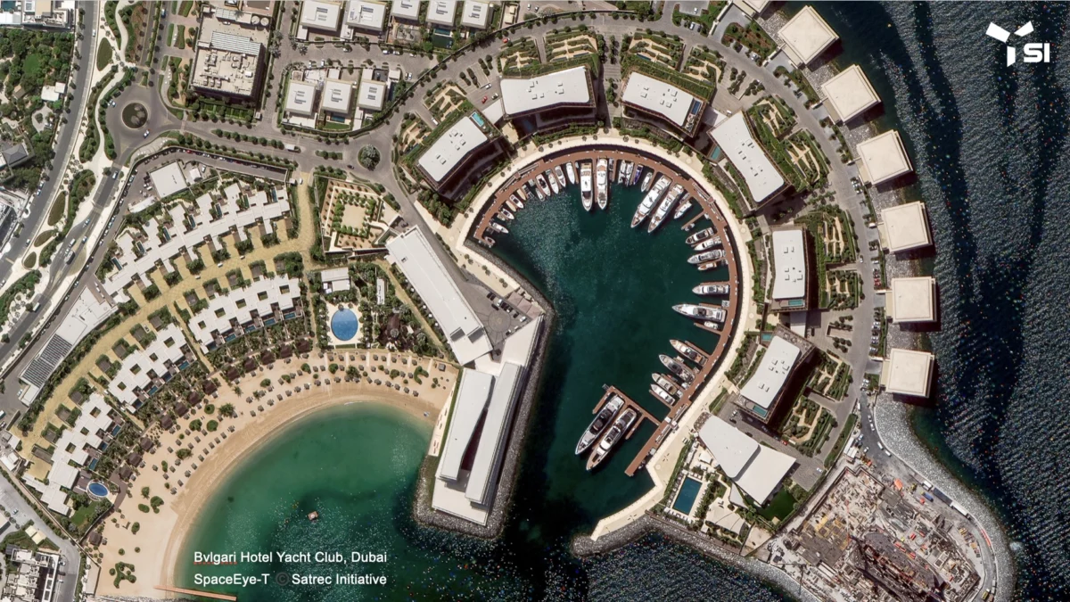
In 2025, Satrec Initiative launched SpaceEye-T, a commercial optical satellite boasting a native resolution of 25 centimeters. SpaceEye-T served as a critical proof-of-concept, establishing Satrec as a viable competitor to established Western imagery providers. The satellite successfully demonstrated high-agility imaging modes, allowing it to capture wide-area strips, single-pass stereo imagery, and multi-point targets in a single orbit.
The SAR and VLEO Announcements (2026)
In July 2026, Hanwha Systems officially unveiled its plans to build and deploy a 64-satellite SAR constellation designed to achieve a sub-30-minute global revisit rate.
Just two months later, at the World Space Business Week (WSBW) conference in Paris, Eugene Kim, Executive Vice President of Satrec Initiative, revealed the final piece of the puzzle: the development of four ultra-high-resolution optical satellites designed to capture 10-centimeter-class imagery from Very Low Earth Orbit (VLEO).
Supporting Data: The Physics and Engineering of VLEO
To achieve 10-centimeter-class resolution without resorting to the massive, multi-ton optical payloads historically used by classified government reconnaissance satellites (such as the U.S. Keyhole series), Satrec and Hanwha are leveraging the physics of Very Low Earth Orbit (VLEO).
The Optical Resolution Equation
The spatial resolution of an optical satellite is fundamentally governed by the diffraction limit, expressed mathematically as:
$$textResolution propto fraclambda cdot HD$$
Where:
$lambda$ is the wavelength of light being captured.
$H$ is the orbital altitude of the satellite.
$D$ is the aperture diameter of the primary telescope mirror.
In a traditional Low Earth Orbit (LEO) of 600 to 800 kilometers, achieving a 10-centimeter resolution requires an exceptionally large primary mirror ($D$), which in turn dictates a massive satellite bus, highly complex launch configurations, and exorbitant manufacturing costs.
By lowering the orbital altitude ($H$) to less than 400 kilometers—into the VLEO regime—Satrec can utilize a significantly smaller, lighter, and less expensive telescope to achieve the same, if not superior, spatial resolution.
┌────────────────────────────────────────────────────────────────────────┐
│                      ORBITAL ALTITUDE COMPARISON                       │
├───────────────────────────────────┬────────────────────────────────────┤
│      TRADITIONAL LEO (600 km)     │            VLEO (<400 km)          │
├───────────────────────────────────┼────────────────────────────────────┤
│ • Moderate atmospheric drag       │ • Severe atmospheric drag          │
│ • Long orbital lifetime (years)   │ • Rapid orbital decay (weeks)      │
│ • Requires large primary mirror   │ • Enables compact, lighter optics  │
│ • Higher latency, wider swath     │ • Lower latency, ultra-high res    │
└───────────────────────────────────┴────────────────────────────────────┘
Overcoming the Hazards of VLEO
Operating in VLEO presents severe engineering challenges that have historically prevented commercial exploitation of this orbital band:
Atmospheric Drag: At altitudes below 400 kilometers, the Earth’s atmosphere is thin but dense enough to exert continuous drag on the spacecraft, causing rapid orbital decay. To counter this, Hanwha’s VLEO satellites will require highly efficient, continuous-thrust propulsion systems—such as electric hall-effect thrusters or air-breathing electric propulsion (ABEP)—to maintain their operational altitude.
Atomic Oxygen Erosion: The upper atmosphere contains highly reactive atomic oxygen (AO), which can chemically erode standard spacecraft materials, degrade thermal blankets, and cloud sensitive optical coatings. Satrec and Hanwha must utilize specialized, AO-resistant materials and protective coatings to ensure spacecraft longevity.
Incremental Testing Strategy: To mitigate these risks, Hanwha has outlined a phased deployment strategy. The company will first launch a prototype test satellite into a stable orbit near 500 kilometers. Over several months, engineers will incrementally lower the satellite’s altitude, gathering empirical data on atmospheric density, drag coefficients, and atomic oxygen degradation before finalizing the design of the remaining three operational spacecraft.
Official Responses: Industry Perspectives and Executive Insights
Speaking to SpaceNews at the World Space Business Week conference in Paris, Eugene Kim, Executive Vice President of Satrec Initiative, emphasized that the integration of SAR, optical, and AI analytics represents a paradigm shift from selling raw pixels to delivering "actionable intelligence."
"Together with ultra-high-resolution SAR and ultra-high-resolution electro-optical, the constellation is expected to open up new opportunities to provide Satellite as a Service in the defense and intelligence field," Kim stated. "Customers will have access to artificial intelligence-based satellite imagery analysis from Satrec Initiative subsidiary SI Analytics for timely and accurate actionable intelligence."
Kim noted that as the Earth observation market matures, end-users are no longer satisfied with static imagery that requires manual interpretation. By utilizing SI Analytics’ automated pipeline, the Hanwha-Satrec constellation can automatically detect military equipment, monitor maritime ports, track supply chain assets, and issue real-time alerts directly to tactical command centers.
The Global Competitive Landscape
Satrec’s aggressive move into the sub-quarter-meter market comes as global commercial remote sensing leaders push toward increasingly finer resolutions. Kim acknowledged this trend, stating that "Satrec Initiative is trying to stay in front" of a highly competitive pack.
┌────────────────────────────────────────────────────────────────────────┐
│                  COMMERCIAL RESOLUTION ROADMAP (2026+)                 │
├─────────────────────────┬────────────────────────┬─────────────────────┤
│ COMPANY                 │ CONSTELLATION / SATELLITE│ NATIVE RESOLUTION   │
├─────────────────────────┼────────────────────────┼─────────────────────┤
│ Satrec Initiative /     │ VLEO Optical           │ 10-cm class         │
│ Hanwha Systems          │                        │                     │
├─────────────────────────┼────────────────────────┼─────────────────────┤
│ Airbus Defense & Space  │ Pléiades Neo Next      │ 20-cm (by 2028)     │
├─────────────────────────┼────────────────────────┼─────────────────────┤
│ Vantor                  │ Vantage                │ 20-cm class         │
├─────────────────────────┼────────────────────────┼─────────────────────┤
│ ImageSat International  │ EROS Nova              │ 25-cm (announced)   │
├─────────────────────────┼────────────────────────┼─────────────────────┤
│ Satrec Initiative (2025)│ SpaceEye-T             │ 25-cm (operational) │
└─────────────────────────┴────────────────────────┴─────────────────────┘
This intense competition highlights a broader industry reality: the distinction between military-grade spy satellites and commercial imaging platforms is rapidly disappearing. A native resolution of 10 centimeters allows analysts to not only detect a vehicle but also identify its specific make, model, and potentially its cargo or modifications—a capability once reserved exclusively for a handful of national intelligence agencies.
Implications: Geopolitics, Defense, and Commercial Markets
The deployment of a co-aligned SAR and ultra-high-resolution optical constellation carries profound implications across multiple domains.
1. South Korean "Space Sovereignty" and Regional Security
For South Korea, the development of this constellation is a critical component of its broader "Space Sovereignty" initiative. Historically reliant on U.S. national technical means for high-resolution reconnaissance over the Korean Peninsula, Seoul has actively sought to establish its own independent, sovereign intelligence, surveillance, and reconnaissance (ISR) capabilities.
A 30-minute revisit rate provided by Hanwha’s 64-satellite SAR fleet, combined with Satrec’s 10-centimeter optical pinpoint verification, will allow South Korean defense forces to continuously monitor North Korean missile sites, mobile launchers, and military installations in near-real-time. Furthermore, this capability enhances South Korea’s position as a key defense exporter, allowing it to package state-of-the-art satellite hardware and intelligence services alongside its existing aerospace and naval defense systems.
2. The Democratization of Tactical Intelligence
The availability of commercial 10-centimeter imagery, combined with rapid-revisit SAR, will democratize tactical intelligence for smaller nations, non-governmental organizations, and commercial entities that lack national space programs.
Maritime Domain Awareness: The constellation will be highly effective at combating illegal, unreported, and unregulated (IUU) fishing, monitoring contested waters in the South China Sea, and securing critical shipping lanes like the Strait of Malacca.
Disaster Response and Insurance: In the wake of natural disasters, the SAR-optical fusion will allow insurance consortia and emergency management agencies to assess structural damage through heavy cloud cover and smoke, optimizing rescue efforts and accelerating claims processing.
3. The Shift to "Satellite as a Service" (SaaS)
By packaging hardware, downlink infrastructure, and AI-driven analytics into a unified subscription or on-demand model, Hanwha and Satrec are challenging the traditional defense procurement paradigm. Rather than purchasing, launching, and operating expensive dedicated satellite fleets, friendly foreign governments can purchase guaranteed tactical tasking rights and analytical outputs.
This lowers the barrier to entry for high-end space capabilities and establishes a highly predictable, recurring revenue stream for the South Korean industrial partners, signaling a new era of commercially driven, militarily relevant space operations.