Introduction
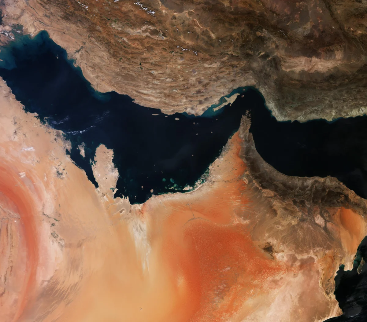
The intersection of space-based intelligence, commercial earth observation, and high-stakes diplomacy has reached a critical juncture. In a significant departure from its foundational commitment to open-access space data, the European Union has mandated a 24-hour delay on the dissemination of satellite imagery covering a strategically sensitive portion of the Gulf of Oman.
The decision, prompted by a formal diplomatic request from the United States, targets imagery generated by the EU’s flagship Copernicus program, specifically its Sentinel-1 and Sentinel-2 satellite constellations. The move highlights the growing tension between Europe’s aspirations for open-source space leadership and the realities of modern geopolitical conflict, particularly the ongoing maritime friction involving the United States, its regional allies, and Iran.
Main Facts of the Decision
The Council of the European Union has enacted a security-driven restriction that alters the operational protocol of its Earth observation network. Under a newly adopted Council decision, the European Commission is required to enforce a mandatory 24-hour embargo on Sentinel-1 and Sentinel-2 imagery for a designated geographical zone within the Gulf of Oman.
Scope of the Restrictions
The restriction is not a blanket global policy but is instead highly localized. The Council’s decision contains an annex outlining five specific sets of latitude and longitude coordinates. Together, these coordinates map out a critical maritime polygon encompassing vital shipping lanes that feed directly into and out of the Strait of Hormuz—the world’s most sensitive energy transit chokepoint.
The technical parameters of the restriction target two distinct types of satellite data:
- Sentinel-1 Imagery: This constellation utilizes Synthetic Aperture Radar (SAR) technology, which can image the Earth’s surface through cloud cover, dust storms, and in complete darkness. SAR is highly valued by military and intelligence analysts for tracking vessel movements, identifying ship drafts, and monitoring port infrastructure regardless of meteorological conditions.
- Sentinel-2 Imagery: This constellation provides high-resolution, multispectral optical imagery. While dependent on daylight and clear skies, Sentinel-2 is crucial for identifying vessel types, detecting wake patterns, and monitoring coastal military installations.
Legal and Administrative Status
The directive was signed on July 13 by Council President Kaja Kallas. Although the decision has not yet been formally published in the EU’s Official Journal, its adoption and existence were validated in a subsequent Council of the EU document dated July 20.
The mechanism used to implement this restriction is the EU’s Space Threat Response Architecture. This operational framework empowers the Council to issue direct, binding security instructions to EU-managed space assets—such as the Copernicus Earth observation fleet and the Galileo satellite navigation system—when a potential threat to the security of the Union, its member states, or its international allies is identified.
Chronology of Events
The implementation of the 24-hour data delay is the latest development in a series of escalations, market shifts, and diplomatic maneuvers that began in early 2024.
[Early March 2024] ──> Direct U.S.-Iran military friction escalates; Planet imposes 96-hour delay.
       │
[April 2024]        ──> U.S. commercial firms (Planet, Vantor) impose indefinite blackout on regional imagery.
       │
[May 2024]          ──> European EO firms experience a surge in demand, marketing unrestricted Copernicus data.
       │
[May 26, 2024]      ──> U.S. issues a formal diplomatic démarche to EU authorities requesting data restrictions.
       │
[June 10, 2024]     ──> EU Political and Security Committee backs the proposed Copernicus data delay.
       │
[July 13, 2024]     ──> Council President Kaja Kallas signs the formal decision imposing the 24-hour delay.
       │
[July 20, 2024]     ──> Internal Council document confirms the adoption and implementation of the directive.
1. The Outbreak of Hostilities (March 2024)
Following a direct escalation in military friction between United States forces and Iranian-backed elements in the Middle East, the U.S. government sought to limit the availability of real-time battlefield intelligence. In response to federal pressure, the San Francisco-based commercial satellite operator Planet Labs imposed a voluntary 96-hour delay on all high-resolution imagery covering the Persian Gulf, the Gulf of Oman, and surrounding territories.
2. Commercial Blackouts (April 2024)
As regional tensions failed to subside, the restrictions tightened. In April, Planet informed its global clientele that it would indefinitely withhold all imagery of the affected region. Vantor (the commercial geospatial intelligence firm formerly known as Maxar Technologies) quietly enacted similar restrictions, severely limiting the flow of commercial optical and radar data to the public domain.
3. The European Loophole (May 2024)
With American commercial providers locked down, global commodity traders, maritime insurers, shipping conglomerates, and investigative journalists turned to European alternatives. Because the EU’s Copernicus program operated under a strict "free and open" data mandate, Sentinel-1 and Sentinel-2 data remained fully accessible in near-real-time. European Earth observation (EO) startups seized the opportunity, marketing their services as uninterrupted alternatives to their restricted American counterparts.
4. The Diplomatic Intervention (May 26, 2024)
Recognizing that the open-access Copernicus program bypassed the security blackout, the United States government delivered a formal diplomatic démarche to European Union authorities. The démarche argued that the rapid availability of Sentinel radar and optical data posed an active security risk, potentially allowing hostile actors—such as Iran or its proxy networks—to track U.S. naval assets, monitor shipping escorts, and coordinate asymmetric maritime attacks.
5. European Consensus and Signing (June–July 2024)
The U.S. request was routed through the EU’s security channels. On June 10, the EU’s Political and Security Committee (PSC) reviewed the geopolitical risks and endorsed the restriction. This culminated in the July 13 executive order signed by Council President Kaja Kallas, officially establishing the 24-hour delay.
Supporting Data and Geopolitical Context
To understand the necessity and impact of the 24-hour delay, it is essential to examine the unique geography of the Gulf of Oman and the strategic capabilities of the Sentinel constellations.
| Coordinate Boundary Point | Strategic Significance | Key Maritime Features |
|---|---|---|
| Point A (North-West) | Entrance to the Strait of Hormuz | Transit lanes for international oil tankers |
| Point B (North-East) | Iranian Territorial Waters | Coastal naval bases and patrol boat staging areas |
| Point C (Central Gulf) | Deepwater Anchorage Zones | Ship-to-ship transfer areas and waiting zones |
| Point D (South-East) | Arabian Sea Transition | U.S. and allied naval escort assembly points |
| Point E (South-West) | Omani Coastline | International shipping lanes and choke-point bypass routes |
The Power of Sentinel-1 and Sentinel-2
The Copernicus Sentinel fleet is widely regarded as the gold standard for public-domain Earth observation.

- Sentinel-1’s C-band Synthetic Aperture Radar (SAR) is particularly sensitive to metal structures on the water. It can easily detect ship hulls, determine their speed and direction via wake analysis, and spot oil slicks associated with illegal dumping or damaged vessels. For a naval force operating in a contested body of water, real-time SAR data is a double-edged sword: it provides situational awareness, but it also reveals the positions of friendly warships to anyone with an internet connection.
- Sentinel-2’s 10-meter spatial resolution is detailed enough to distinguish between a commercial container ship, an oil tanker, and a military destroyer.
Why a 24-Hour Delay Matters
In modern naval warfare, targeting information is highly perishable. Tactical decisions—such as launching anti-ship cruise missiles, deploying sea-skimming drones, or staging fast-attack craft raids—rely on targeting data that is minutes or, at most, a few hours old. By forcing a 24-hour delay on Sentinel data, the EU effectively neutralizes the tactical utility of the imagery for real-time targeting, while still preserving its long-term scientific, environmental, and analytical value for academic and non-military researchers.
Official Responses and Policy Frameworks
The imposition of the data delay has sparked debate over the governance of the Copernicus program and the limits of Europe’s open-data philosophy.
The European Commission’s Stance
When questioned about the departure from the program’s foundational principles, a European Commission spokesperson defended the decision as a necessary and routine application of existing legal safeguards.
"The Copernicus programme operates under a free and open data policy, ensuring that its satellite imagery is available to users worldwide in accordance with applicable regulations and operational considerations. However, limitations to this policy for security reasons are allowed. This is a technical measure to protect against possible security risks. It is a common measure, also being taken by many other satellite operators."
The Legal Basis for Shutter Control
While Copernicus is celebrated for its open-access model, the regulatory framework governing the program has always contained national security "shutter control" clauses. Under the Copernicus Regulation, the European Commission, in coordination with member states and the Council, reserves the right to restrict access to data feeds in the event of:
- An imminent threat to the essential security interests of the Union or its Member States.
- An emergency situation requiring immediate humanitarian or defense coordination.
- A formal activation of the Space Threat Response Architecture under the EU’s Common Security and Defence Policy (CSDP).
By framing the action as a "technical measure" rather than a political concession, European officials are attempting to minimize the precedent this sets for future geopolitical crises.
Implications for the Earth Observation Market
The EU’s decision to restrict Sentinel data has profound implications for the commercial geospatial intelligence sector, international trade, and the concept of European strategic autonomy.
                        ┌────────────────────────┐
                        │  U.S. Security Appeal  │
                        └───────────┬────────────┘
                                    │
                                    ▼
                        ┌────────────────────────┐
                        │   EU Imposes 24-Hour   │
                        │   Copernicus Delay     │
                        └───────────┬────────────┘
                                    │
            ┌───────────────────────┴───────────────────────┐
            ▼                                               ▼
┌────────────────────────┐                      ┌────────────────────────┐
│ Commercial Disruptions │                      │  Strategic Realignment │
├────────────────────────┤                      ├────────────────────────┤
│ • Loss of "unrestricted"│                      │ • Compromised European │
│   marketing advantage  │                      │   strategic autonomy   │
│ • Commodity traders &  │                      │ • Precedent set for    │
│   insurers lose data   │                      │   future global crises │
│ • Increased reliance on│                      │ • Alignment of Western │
│   private radar firms  │                      │   space security policies│
└────────────────────────┘                      └────────────────────────┘
1. Erosion of the "European Alternative" Advantage
In the weeks following the initial U.S. commercial blackout in April, European EO companies like the Paris-based environmental intelligence firm Kayrros experienced a surge in business. Executives openly praised Copernicus for its resilience and lack of political interference.
Antoine Rostand, president and co-founder of Kayrros, noted in May: "The good news is that in Europe we have Copernicus, which kept operating with no restrictions."
With the implementation of the July 13 decision, this competitive advantage has evaporated. European startups can no longer offer global energy traders, maritime insurers, and shipping companies an unrestricted window into the Strait of Hormuz. The playing field between U.S. and European commercial analytics firms has been forcibly leveled, to the detriment of European commercial operators who had capitalized on the regulatory divergence.
2. Impact on Global Maritime Transparency
The 24-hour delay severely limits the ability of non-governmental organizations (NGOs), maritime watchdogs, and investigative journalists to independently verify events in the Gulf of Oman. Historically, open-source intelligence (OSINT) analysts have used Sentinel data to:
- Document illegal oil-to-oil transfers at sea.
- Track the movements of sanctioned Iranian oil tankers.
- Investigate claims of naval harassment and state-sponsored piracy.
By delaying this data, the EU and the U.S. have effectively restricted independent oversight of a highly volatile conflict zone, leaving the public dependent on official government press releases and selected declassified intelligence.
3. The Question of European Strategic Autonomy
For years, EU leaders have championed "strategic autonomy"—the idea that Europe should possess independent technological, military, and space capabilities so it does not have to rely on the foreign policy priorities of the United States.
By acceding to a U.S. diplomatic démarche and modifying the operation of its own multi-billion-euro space program, the EU has demonstrated that when national security interests collide, transatlantic alignment often takes precedence over strategic independence. This decision may set a precedent, signaling to other global powers that Europe’s open-data commitments are subject to revision under diplomatic pressure from Washington.